Monday, December 30, 2013

Check In from Pleasant Mountain

View west from the summit of Pleasant Mountain
Jay's Spot Beacon
Latitude:44.02701
Longitude:-70.82263
GPS location Date/Time:12/30/2013 15:22:27 EST

Message:Jay Meyer has checked in. At the time of this message he was OKAY at the location shown and did not need help.

Click the link below to see where I am located.
http://fms.ws/F4w6q/44.02701N/70.82263W

If the above link does not work, try this link:
http://maps.google.com/maps?f=q&hl=en&geocode=&q=44.02701,-70.82263&ll=44.02701,-70.82263&ie=UTF8&z=12&om=1

Jay's Spot Beacon

You have received this message because Jay's Spot Beacon has added you to their SPOT contact list.

Ready for Adventure
FindMeSPOT.com

Saturday, December 28, 2013

Four Hikes with my Dad


Fred Josef Meyer, January 1, 1931-December 27, 2013
It is better to light a candle than curse the darkness.
Chinese Proverb

People sometimes ask me how I got started in mountaineering.  The answer is that I first developed my love for mountain exploration on hikes with my Dad.  But I did not just hike with my Dad when I was young; he has been a hiking companion for me throughout my life.  I would like to share four special hikes that I took with him over the years.

The Jungfraujoch in Switzerland's Berner Oberland
My Dad hiked often in the mountains of Switzerland – his birthplace – and wanted to share his love of skiing and the outdoors with me and my two brothers.  In what might now be called my “tween” years, he took us on a camping and skiing trip to Tuckerman Ravine on Mount Washington in New Hampshire.  It was my first visit to a place that is now as familiar as an old friend.  We carried overstuffed backpacks heavily laden with the latest gear and dehydrated food; honestly I do not know how my younger brothers made it all the way up to Hermit Lake, where we endured a cold night in thin summer sleeping bags.  The next day we skied Tuckerman’s Bowl, earning our turns by climbing up a boot ladder of steps kicked into the steep face.  The same technique served me well years later on the summit pyramid of Bolivia’s Huayna Potosi and the headwall of McKinley’s West Buttress.


On the Niederhorn in Switzerland's Berner Oberland
In the summer of 1982 I had just finished my freshman year at Dartmouth and was preparing for a semester abroad in Germany.  My Dad was working in Bern, Switzerland, and I stayed with him and my stepmother while working at a resort in the mountain village of Sigriswil.  He was 51 at the time – close to my current age – and grappling with many of the issues of personal identity, family and career often encountered in those mid-life years.  I was 19, and grappling with much different issues of my own.  One sunny afternoon we hiked to the summit of the nearby Sigriswiler Rothorn, where we enjoyed a fine view of the long narrow Justistal valley lying far below.  It was a priceless opportunity for us to leave our daily troubles behind and simply walk and spend time together in a gorgeous setting.

The Pecos Wilderness in New Mexico
On flights home from Europe Dad sometimes admired the view of Katahdin, and he knew that I had been there often and loved what Maine’s Penobscots named “the Greatest Mountain.”  In the summer of 2002, as I was training for my expedition to McKinley, he and two friends joined me for a hike to the highest point in Maine.  Our chosen route – the Hunt Trail – is steep and rocky in places and features iron rungs set into boulders in some of the roughest sections.  I had the honor of helping him up one of those difficult spots with a long forceful push on his derriere!  I was also glad to render first aid when he cut his leg on a rock.  Despite these challenges, we reached the summit in an effort that he proudly remembered later.  After our day toiling together, he told me that he knew I was ready for the mountain that Alaska’s Athabaskans named “the Great One.”

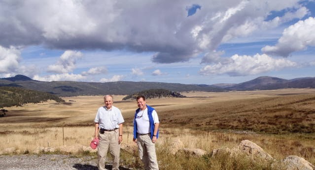
Sandia Peak in New Mexico
My last long hike with Dad was in September, 2012, while Allison and I were visiting him and my stepmother in Santa Fe, New Mexico.  For some time he had wanted to hike in the nearby Valle Grande – a dramatic volcanic caldera many miles in diameter – and our visit was the perfect opportunity.  I was under great pressure at work, and relished the chance to escape a stream of urgent messages on my Blackberry.  He was participating in a clinical trial of a new chemotherapy drug, and we carried the day’s doses in a cooler as we drove through the Jemez Pueblo to the hike.  Our 7 mile route circumnavigated the Cerros del Abrigo, an eruptive dome jutting from the center of the giant valley.  All around us, for hours, elk hidden in the woods near and far bugled their eerie call and spoke to us in a timeless language of the mountains.    

Of all the places that he knew, this valley alone could reflect the great spatial majesty of the sky. It scooped out of the dark peaks like the well of a great, gathering storm, deep umber and blue and smoke-colored. The view across the diameter was magnificent; it was an unbelievably great expanse. As many times as he had been there in the past, each new sight of it always brought him up short, and he had to catch his breath. Just there, it seemed, a strange and brilliant light lay upon the world, and all the objects in the landscape were washed clean and set away in the distance.
N. Scott Momaday, House Made of Dawn

The Valle Grande in New Mexico

Friday, December 20, 2013

Check In from the Boundary Trail on Bradbury Mountain

Allison on Bradbury Mountain

Jay's Spot Beacon
Latitude:43.90191
Longitude:-70.18173
GPS location Date/Time:12/20/2013 14:35:21 EST

Message:Jay Meyer has checked in. At the time of this message he was OKAY at the location shown and did not need help.

Click the link below to see where I am located.
http://fms.ws/E--qe/43.90191N/70.18173W

If the above link does not work, try this link:
http://maps.google.com/maps?f=q&hl=en&geocode=&q=43.90191,-70.18173&ll=43.90191,-70.18173&ie=UTF8&z=12&om=1

Jay's Spot Beacon

You have received this message because Jay's Spot Beacon has added you to their SPOT contact list.

Ready for Adventure
FindMeSPOT.com

Wednesday, December 18, 2013

Franconia Ridge


Franconia Ridge from Mt. Lafayette; Mt. Lincoln in foreground

On December 14, I hiked the Franconia Ridge in New Hampshire with my friends Rick and Hugh.

Mt. Lafayette (l.) and Mt. Lincoln (r.)

The Franconia Ridge rises to the east of Franconia Notch, a deep and narrow cleft in the White Mountains between Mount Lafayette on the east Cannon Mountain on the west.  From Mount Lafayette, the Franconia Ridge runs south over Mount Lincoln, Little Haystack, Mount Liberty and Mount Flume; however, our loop went only as far as Little Haystack.

Rick and Hugh on the summit of Mt. Lafayette

We started hiking up the Old Bridle Path around 8 a.m.; the temperature was around zero Fahrenheit.  After stopping at the Greenleaf Hut to adjust our gear, we continued up to the summit of Mount Lafayette.

Presidential Range (on horizon) from Mt. Lafayette

Although cold, it was a sunny morning and we enjoyed expansive views from Lafayette's summit.  To the northeast lay the Presidential Range crowned by Mount Washington, and Cannon Mountain was close by across Franconia Notch.  Far in the distance, we could see Mount Mansfield and Camel's Hump in Vermont.

Cannon Mountain from Mt. Lafayette

From Mount Lafayette, we continued along the spine of Franconia Ridge.  Descending into dips and rising over icy, rocky peaks, we passed over Mount Lincoln and on to the summit of Little Haystack.

Rick on Mt. Lincoln

From Little Haystack we descended into the woods and down the Falling Waters trail, named for the beautiful waterfalls that it crosses.  The falls were frozen cascades of blue ice when we crossed them, providing a dramatic conclusion to our cold but fulfilling day in the White Mountains.

Mt. Flume, Mt. Liberty and Little Haystack from Mt. Lincoln

Wednesday, October 30, 2013

Southeast Florida

Key West Marina
In late June and early July, Allison and I traveled to southeast Florida.  We visited Miami, Key West and Key Largo before ending our trip in Hobe Sound with Allison’s father over the Fourth of July.

South Beach, Miami
Our first stop was at Miami’s South Beach.  After checking into the modern and stylish Gale Hotel, we walked along the beach to a restaurant in the heart of the lively Art Deco District.  We ate dinner at a  table on the sidewalk, watching a parade of revelers bathed in the district’s iconic neon glow.

Miami's Art Deco District
The next day Allison and I lounged on the beach, surrounded mostly by Argentineans and Brazilians escaping the southern hemisphere’s winter.  We were soon surprised to find ourselves in the midst of a television production set; a Latin American variety show was filming an episode on the beach!  Comedians, bikini-clad models and one very special little DJ amused us for hours.

Filming a variety show on South Beach
South Beach out of the (beat) box!
(click for video)
From Miami we drove south through the keys on Route 1, crossing miles of bright blue water interspersed by low-lying islets.  After several hours of scenic driving we arrived at Key West, the quirky and boisterous “Conch Republic.”

The Southernmost Point
In Key West we first walked to the Southernmost Point, where a monument marks the southern extremity of the continental United States.  Allison and I snapped a few quick photos in oppressive heat and humidity, then window shopped our way up Duval Street to Mallory Square for the sunset.

Sunset at Mallory Square
I dove the next day while Allison relaxed in the sun.  I had planned to dive with Lost Reef Adventures on the USS VANDENBERG – a sunken satellite tracking ship – but strong current prevented dives on the wreck so we explored two local reefs instead.  Afterward Allison and I wandered the waterfront, then returned to Duval Street for a delicious Italian dinner and evening walk among the raucous crowd.

Hawksbill Sea Turtle
In the morning we had breakfast at the Southernmost Beach Cafe, then began our drive back from Key West at Mile 0 on Route 1.  In the hot June sun, Allison and I remembered that the temperature had been well below zero in January when we were at Route 1’s other end in Fort Kent, Maine!  After a lovely drive through the Keys, we spent a relaxing evening in Key Largo before heading further north to spend the Fourth of July with Allison’s father Jack.

The end  . . .
 
. . .  or the beginning?
Jack lives in Hobe Sound, on the Atlantic coast near West Palm Beach.  His home is close to a beautiful beach at the Hobe Sound National Wildlife Refuge.  Also nearby is Jupiter Inlet, an important passage from the Indian River into the Atlantic.  During our visit I took a dive trip out of Jupiter Inlet with Jupiter Dive Center, viewing sharks, sea turtles, and the huge goliath grouper (each weighing hundreds of pounds) which frequent the area.
 
Goliath Grouper (each approximately 5' long)
In southeast Florida, Allison and I explored new places and also returned to some familiar favorites.  We combined sightseeing, relaxation in the sun, watersports and time with family.  And we visited the southernmost point in the continental United States as part of our journey to America’s corners.  It was fitting to end our trip with a celebration of America’s birthday!

Nurse Shark

Wednesday, October 16, 2013

Check In from the Crockers

North Crocker and the Crocker Cirque

Jay's Spot Beacon
Latitude:45.04709
Longitude:-70.38278
GPS location Date/Time:10/15/2013 11:26:27 EDT

Message:Jay Meyer has checked in. At the time of this message he was OKAY at the location shown and did not need help.

Click the link below to see where I am located.
http://fms.ws/EEmMk/45.04709N/70.38278W

If the above link does not work, try this link:
http://maps.google.com/maps?f=q&hl=en&geocode=&q=45.04709,-70.38278&ll=45.04709,-70.38278&ie=UTF8&z=12&om=1

Jay's Spot Beacon

You have received this message because Jay's Spot Beacon has added you to their SPOT contact list.

Ready for Adventure
FindMeSPOT.com

Friday, October 4, 2013

Inland Washington and Oregon

The Columbia River Gorge
In late April and May, Allison and I spent four weeks traveling through Alaska and the Pacific Northwest.  This post describes the final portion of that trip: inland Washington and Oregon, including the Yakima Valley, Mount Hood and Portland, Oregon.

The Bonair Winery in Zillah, Washington
Heading out of Seattle on I-90, we quickly left the urban landscape behind and ascended into the heavily wooded Cascade Mountains.  East of Snoqualmie Pass our surroundings changed dramatically, from verdant temperate rainforest to much drier agricultural land and scrubby plains.  After a few hours we reached our destination for two days and nights: the Yakima Valley.

A vineyard in the Rattlesnake Hills above Zillah, Washington
In hills above the Yakima Valley, the region’s fertile soil and bright sunshine foster many fruits including red and white grape varieties, pears, cherries and apples.  Vegetables and other truck crops are also grown there; asparagus was being harvested during our visit, and we enjoyed it several times at local restaurants.  Throughout the valley, latino farmworkers are a dominant and colorful cultural influence.

Wine tasting in Prosser, Washington
Yakima Valley’s bountiful vineyards make it one of America’s primary winemaking centers, hosting vintners ranging from giants like Columbia Crest to specialty labels like Hogue and tiny craft wineries like Knight Hill.  One day we drove among vineyards in the Rattlesnake Hills above Zillah, stopping and tasting at family operated wineries along the way.  The next day we visited Prosser, where tasting rooms and restaurants catering to oenophiles cluster in close proximity to each other.  We ended our tour with a newfound appreciation of American winemaking, and also a few boxes of bottles destined for home and family!

Wheat fields in the Horse Heaven Hills
The Columbia River Gorge
Having sampled the fruit of the vine to our hearts’ content, we drove south from the Yakima Valley through thousands of acres of wheat fields forming a bright green carpet extending for miles in every direction.  After reaching the Columbia River we turned west, passing through the scenic Columbia River Gorge and then into Oregon near The Dalles.

Orchards south of The Dalles, Oregon
Leaving the highway, we quickly became lost in a maze of back roads leading through scenic orchards and into deep woodlands of the Mount Hood National Forest.  Eventually we emerged on the east side of Mount Hood and proceeded to our next destination: the impressive Timberline Lodge, high on Mount Hood above the town of Government Camp.

Timberline Lodge on Mount Hood
An old familiar place on Mount Hood
I had visited Timberline Lodge several times previously on mountaineering trips, and we were now excited to stay there together.  Located aside the Palmer Glacier, this monumental stone and timber lodge was built as a Works Progress Administration project during the Great Depression; it was dedicated by Franklin D. Roosevelt in 1937.  Our room was a comfortable and well maintained testament to the building’s historic roots, with excellent views uphill through scattered spruce glades leading to the glacier.

Snow and fondue on Memorial Day Weekend!
A fireplace at Timberline Lodge
Mount Hood receives prodigious amounts of snow in the Spring, and although it was Memorial Day weekend we arrived in a snowstorm which produced nearly a foot of heavy powder.  Allison and I admired the wintry landscape from a window table in the cozy and romantic upper dining room, enjoying cheese fondue while warmed by a fire in the gigantic stone hearth.  The next morning I skied a dozen or so runs in newly fallen snow while Allison relaxed fireside in the lodge.

Rose Festival in Portland, Oregon

Portland streetcar
After my morning of skiing, we departed Mount Hood for the trip’s final destination: Portland, Oregon.  Known as the “City of Roses”, Portland was in full colorful bloom both literally and figuratively.  The annual Rose Festival was underway on the banks of the Willamette River, and we rode a modern streetcar downtown to enjoy the festival and walk through some of the city’s vibrant public spaces.

Still at the Clear Creek Distillery
One of our favorite discoveries in Portland was the funky but stylish Nob Hill district, where we stayed.  Nob Hill features many lively restaurants, nightspots and stores; all were within easy walking distance of our hotel.  We particularly enjoyed touring the Clear Creek Distillery, which produces eau de vie fruit brandies such as Kirschwasser and Poire Williams.  Equally memorable was the Peculiarium, a hybrid novelty shop and museum which was grotesque yet oddly welcoming.

Alien autopsy at the Peculiarium
Sasquatch attack!
Our visit to Portland marked the end of our month-long trip through Alaska and the Pacific Northwest.  After such extended travels we looked forward to returning home, but were sorry that our time in the lovely and interesting Rose City had been so short.  We had discovered many treasures in our explorations, but still had much more awaiting us in our continuing journey to America’s corners.
 
Say hello to my little friends!  Public art in Portland, Oregon

Friday, September 20, 2013

Check In from Jeffrey's Ledge


Fred's big pollock caught on Jeffrey's Ledge

Jay's Spot Beacon
Latitude:43.13763
Longitude:-70.06650
GPS location Date/Time:09/18/2013 10:40:30 EDT

Message:Jay Meyer has checked in. At the time of this message he was OKAY at the location shown and did not need help.

Click the link below to see where I am located.
http://fms.ws/DugTa/43.13763N/70.06650W

If the above link does not work, try this link:
http://maps.google.com/maps?f=q&hl=en&geocode=&q=43.13763,-70.06650&ll=43.13763,-70.06650&ie=UTF8&z=12&om=1

Jay's Spot Beacon

You have received this message because Jay's Spot Beacon has added you to their SPOT contact list.

Ready for Adventure
FindMeSPOT.com

Tuesday, September 10, 2013

Mount Adams via King Ravine

King Ravine, with the Great Gully at center

On August 20, 2013, I climbed to the summit of Mount Adams in New Hampshire.  Mount Adams is the second highest mountain in the northeast; it is located north of Mount Washington, in the Presidential Range.

Waterfall along the King Ravine Trail
I reached the summit through King Ravine, a deep bowl on the mountain’s north side.  I hiked on the King Ravine Trail, a rugged trail which follows a rocky stream and passes among many huge boulders at the base of the ravine.

Boulder cave on the Subway
(note arrow trail marker at center) 
Hiking through King Ravine, I took a short detour on the Subway Trail which squeezes through several narrow cracks and caves formed by the jumbled boulders.

Waterfall in the Great Gully
To ascend the ravine’s steep wall, I took the spectacular Great Gully Trail.  The AMC White Mountain Guide describes the Great Gully Trail as “extremely steep and rough” and “lightly used and marked,” with “one particularly difficult scramble.”  I found the challenging trail fun and exciting!

Mount Madison from Mount Adams
From the top of the Great Gully Trail, it was a short hike through Thunderstorm Junction to the top of Mount Adams.  The summit was partially obscured by blowing clouds, but I still enjoyed a dramatic view of nearby Mount Madison.

Randolph Valley from the Air Line
(King Ravine left and Durand Ridge right of center)
I descended from the summit back to my car on the Air Line, a particularly scenic trail which follows the crest of Durand Ridge.  From the Air Line, I had an excellent view of my ascent route up the Great Gully in King Ravine.


King Ravine from the Air Line
(Great Gully slightly right of center)