Monday, July 22, 2013

Alaska's Panhandle and the Inside Passage

 
Underway in the Inside Passage off British Columbia
In late April and May, Allison and I spent four weeks traveling through Alaska and the Pacific Northwest.  This post describes the third portion of the trip: a three day ferry passage from Juneau, Alaska to Bellingham, Washington on board the M/V COLUMBIA.

The M/V Columbia in Sitka
Alaska's panhandle is a narrow coastal strip of land located southeast of central Alaska, between Canada and the Pacific Ocean.  Although it holds a number of important cities - including Juneau, Alaska's capital - much of the panhandle is accessible only by boat or plane and not by road.  Its climate is wetter and milder than the rest of Alaska; much of it is temperate rain forest, similar to coastal Washington or Oregon.  Several large national parks or forests, including Wrangell-St. Elias National Park and the Tongass National Forest, are located on the panhandle.

Footbridge constructed from a single large log,
 in the Tongass National Forest near Sitka
We traveled down the panhandle via the Inside Passage, a shipping route which winds through the myriad islands of the Alaskan panhandle and Canada's British Columbia.  The Inside Passage is largely protected from rough seas in the Pacific Ocean, although there are some short sections exposed to open water.

Lighthouse on the Inside Passage
The M/V COLUMBIA is the largest ferry operated by the Alaska Marine Highway System, an indispensable and excellent state ferry network serving many areas of coastal Alaska.  She is a large yet highly maneuverable vessel, 418' long and capable of carrying 600 passengers and many large and small vehicles including trucks and buses.

Governor's residence in Juneau (Russia not visible)
 
Near Juneau's cruise ship terminal
 
Before boarding the ferry, we flew from Anchorage to Juneau and spent a day touring Alaska's capital.  We walked by the Governor's residence and state house, then explored Juneau's commercial center and Gold Rush era historic district.  The city is an important cruise ship port during the summer season, which was only beginning when we visited.  It has shops, restaurants and bars to serve the tourist trade; several good book stores allowed us to stock up on reading material for our ferry trip.

A rainy morning at Juneau's ferry terminal
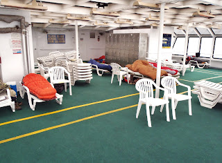
Early the next morning we boarded the M/V COLUMBIA and settled into our cabin.  We had booked a four bunk cabin - the largest available - to obtain a full private bathroom with shower.  The large cabin had plenty of space for us to store our luggage, spread out and enjoy the trip in comfort.  Compared with many of the other passengers, our accommodations were quite luxurious; it is common for passengers to sleep in the vessel's lounge chairs, or in sleeping bags or tents on the partially enclosed solarium deck.

Our cabin's bunks and sitting area

The cheap seats!
In addition to several day lounges, the M/V COLUMBIA also has a movie theater and two restaurants: one cafeteria style with a broad variety of convenient meals and snacks, and the other a dining room featuring finer fare including Alaskan seafood.  Allison and I spent time reading in the lounges or our cabin, and enjoyed walking and sunning on the ship's several decks when the weather was suitable.

The M/V COLUMBIA's dining room
The M/V COLUMBIA's cafeteria
During our trip the M/V COLUMBIA stopped in a number of ports to pick up and discharge passengers and vehicles.  Some of the stops were quite short or at inconvenient times (e.g., early morning), but others were long enough for us to go ashore and explore.  During our stop in Sitka it was raining heavily, but I nevertheless enjoyed a couple of hours hiking on nearby trails in the Tongass National Forest.  The rain created an appropriately misty atmosphere for the dense, mossy rainforest.

Western Skunk Cabbage ("Swamp Lantern")
blooms in the Tongass National Forest
Allison and I also walked through downtown Ketchikan - like Juneau a historic gold rush city and important cruise ship port.  We toured the well preserved Creek Street district, with colorful nineteenth century houses and shops on a boardwalk along the creek.  Totem poles are prominently displayed throughout much of Alaska's panhandle, and Ketchikan has many large ones created by the Tlingit tribe.

Creek Street in Ketchikan
Tlingit totem pole in Ketchikan
Our final day on board the M/V COLUMBIA was spent steaming through Canadian waters off British Columbia.  Fortunately the weather was sunny and beautiful, so we could spend time on deck enjoying the stunning scenery passing by to port and starboard.  We saw small villages, lighthouses and other vessels plying the Inside Passage along with us.  It was a suitable ending for this very relaxing and enjoyable phase of our trip.  Early the next morning, we disembarked in Bellingham, Washington to begin the trip's next phase: northern Washington, including the San Juan Islands and Seattle.

Underway in the Inside Passage off British Columbia
  

Monday, July 15, 2013

Alaska's Kenai Peninsula

Turnagain Arm
In late April and May, Allison and I spent four weeks traveling through Alaska and the Pacific Northwest.  This post describes the second portion of that trip: a week exploring Alaska's Kenai Peninsula, including Homer, Seward and the Turnagain Arm region.


A sea otter in Kachemak Bay 
The Kenai Peninsula is located south of Anchorage, between Cook Inlet and Prince William Sound.  It has miles of beautiful shoreline with many glacial fjords, and a mountainous interior bejeweled with pristine alpine lakes.  We visited the Kenai Peninsula after first exploring Alaska's interior, and its coastal landscape was in marked contrast to the remote snowy wilderness between Anchorage and Fairbanks.

Visiting Homer's Boat Harbor
Our first stop on the Kenai Peninsula was in Homer, the halibut fishing capital of the world.  Allison and I relish halibut's delicate flavor, and she was excited to try her luck at catching some!  After a long but scenic drive south from Anchorage, we arrived at Homer's harbor and met Captain Pete who would be taking us out the next day on the F/V JULIA LYNN.  Pete was exceptionally friendly and generous; he gave us several pounds of filleted halibut which he had caught that day, and suggested that we take it to Captain Pattie's Restaurant which would cook it to order.  His advice was right on the money, and that evening we enjoyed a delicious dinner of the freshest fish imaginable.

With Captain Pete on board the F/V JULIA LYNN
Early the next morning we boarded the F/V JULIA LYNN and Captain Pete motored approximately 17 miles to the mouth of Kachemak Bay, where we spent the day bottom fishing in approximately 175' of water using chunks of salmon and herring for bait.  The bite was slow but steady, and at the end of the day each of us had caught and kept our limit of two good sized halibut while releasing quite a few smaller fish.  Allison also reeled in two large pacific cod.  The halibut were 10-15 pounds each rather than the hundred plus pound "barn door" giants often caught in these waters later in the season, but ours would be much better table fare.  We arranged with a local processor to have our fillets vacuum packed, frozen and shipped home, and have been enjoying them greatly.


Allison with a pacific cod
A day's catch of halibut
After our full day on the water, we made the long drive back north to the Alyeska Resort in Girdwood on Turnagain Arm.  Fortunately, in May the sun sets very late in Alaska and it was still twilight after 11 p.m. when we arrived at the hotel.  The Alyeska Resort is Alaska's largest and best known ski area, located in the Chugach mountains about 45 minutes south of Anchorage.  The resort has a large, modern hotel where we spent six nights while exploring the Turnagain Arm region and making day trips to various destinations on the peninsula.

The Alyeska ski resort in Girdwood
The Hotel Alyeska
One day we drove to Seward, a fishing harbor at the northern end of a glacial fjord fringed by snowy mountain peaks.  Allison and I hiked several miles over an icy, rocky trail to Tonsina Point where we wandered along the shoreline enjoying stunning views of the fjord.

Hiking at Tonsina Point, outside Seward
Another day, I hiked to the Crow Creek Gold Mine in the mountains outside Girdwood while Allison relaxed at the resort.  Mountain goats clambered up and down rocky slopes above the mining site.  My path crossed the route of the famed Iditarod dog sled race, which continues on over a pass leading through the mountains toward Anchorage.

Mountains above the Crow Creek Gold Mine
Curious about Alaskan history and native culture, Allison and I drove into nearby Anchorage and spent an afternoon at the Anchorage Museum.  There we viewed exhibits on a variety of topics including the divers tribes native to Alaska, and the vital, colorful role of aviation in Alaskan history.  We found the extensive displays of native clothing and artifacts particularly interesting.  That night we enjoyed an excellent meal at Orso - the same restaurant where I dined with my climbing team before our successful expedition to the summit of Denali (Mt. McKinley) in 2003.

Native clothing and artifacts
at the Anchorage Museum
An aviation exhibit at the Anchorage Museum
We spent our final day on the Kenai Peninsula exploring the former site of Portage, at the end of Turnagain Arm.  This area was the epicenter of the disastrous "Good Friday Earthquake" in 1964.  At a magnitude of 9.2 it was one of the strongest earthquakes in recorded history, causing 143 deaths, destructive tsunamis and extensive property damage.  The town of Portage was abandoned after sinking approximately ten feet and flooding as a result of the earthquake.  We viewed several nearby glaciers, including the Portage Glacier and beautiful Portage Lake which lies below it.  We also walked through the Alaska Wildlife Conservation Center, home to many bears, reindeer (caribou), bison and other animals.

Viewing Portage Lake and the Portage Glacier
A black bear at the Alaska Wildlife Conservation Center
Over our week on the Kenai Peninsula, Allison and I had the opportunity to explore the region's many attractions thoroughly but at a leisurely pace.  At the end of the week, we were excited to begin the next phase of our journey: a trip through Alaska's Panhandle and down the Inside Passage on the wonderful Alaska Marine Highway ferry system.

A mountain lake on the Seward Highway
  

Friday, July 5, 2013

Check In from the Southernmost Point, in Key West

The Southernmost Point in the continental United States


Jay's Spot Beacon
Latitude:24.54654
Longitude:-81.79745
GPS location Date/Time:06/27/2013 18:19:22 EDT

Message:Jay Meyer has checked in. At the time of this message he was OKAY at the location shown and did not need help.

Click the link below to see where I am located.
http://fms.ws/CfySW/24.54654N/81.79745W

If the above link does not work, try this link:
http://maps.google.com/maps?f=q&hl=en&geocode=&q=24.54654,-81.79745&ll=24.54654,-81.79745&ie=UTF8&z=12&om=1

Jay's Spot Beacon

You have received this message because Jay's Spot Beacon has added you to their SPOT contact list.

Ready for Adventure
FindMeSPOT.com

Check In from Miami's South Beach

Filming a variety show on South Beach


Jay's Spot Beacon
Latitude:25.79433
Longitude:-80.12600
GPS location Date/Time:06/26/2013 12:16:35 EDT

Message:Jay Meyer has checked in. At the time of this message he was OKAY at the location shown and did not need help.

Click the link below to see where I am located.
http://fms.ws/Cecc2/25.79433N/80.12600W

If the above link does not work, try this link:
http://maps.google.com/maps?f=q&hl=en&geocode=&q=25.79433,-80.12600&ll=25.79433,-80.12600&ie=UTF8&z=12&om=1

Jay's Spot Beacon

You have received this message because Jay's Spot Beacon has added you to their SPOT contact list.

Ready for Adventure
FindMeSPOT.com