Monday, July 15, 2013

Alaska's Kenai Peninsula

Turnagain Arm
In late April and May, Allison and I spent four weeks traveling through Alaska and the Pacific Northwest.  This post describes the second portion of that trip: a week exploring Alaska's Kenai Peninsula, including Homer, Seward and the Turnagain Arm region.


A sea otter in Kachemak Bay 
The Kenai Peninsula is located south of Anchorage, between Cook Inlet and Prince William Sound.  It has miles of beautiful shoreline with many glacial fjords, and a mountainous interior bejeweled with pristine alpine lakes.  We visited the Kenai Peninsula after first exploring Alaska's interior, and its coastal landscape was in marked contrast to the remote snowy wilderness between Anchorage and Fairbanks.

Visiting Homer's Boat Harbor
Our first stop on the Kenai Peninsula was in Homer, the halibut fishing capital of the world.  Allison and I relish halibut's delicate flavor, and she was excited to try her luck at catching some!  After a long but scenic drive south from Anchorage, we arrived at Homer's harbor and met Captain Pete who would be taking us out the next day on the F/V JULIA LYNN.  Pete was exceptionally friendly and generous; he gave us several pounds of filleted halibut which he had caught that day, and suggested that we take it to Captain Pattie's Restaurant which would cook it to order.  His advice was right on the money, and that evening we enjoyed a delicious dinner of the freshest fish imaginable.

With Captain Pete on board the F/V JULIA LYNN
Early the next morning we boarded the F/V JULIA LYNN and Captain Pete motored approximately 17 miles to the mouth of Kachemak Bay, where we spent the day bottom fishing in approximately 175' of water using chunks of salmon and herring for bait.  The bite was slow but steady, and at the end of the day each of us had caught and kept our limit of two good sized halibut while releasing quite a few smaller fish.  Allison also reeled in two large pacific cod.  The halibut were 10-15 pounds each rather than the hundred plus pound "barn door" giants often caught in these waters later in the season, but ours would be much better table fare.  We arranged with a local processor to have our fillets vacuum packed, frozen and shipped home, and have been enjoying them greatly.


Allison with a pacific cod
A day's catch of halibut
After our full day on the water, we made the long drive back north to the Alyeska Resort in Girdwood on Turnagain Arm.  Fortunately, in May the sun sets very late in Alaska and it was still twilight after 11 p.m. when we arrived at the hotel.  The Alyeska Resort is Alaska's largest and best known ski area, located in the Chugach mountains about 45 minutes south of Anchorage.  The resort has a large, modern hotel where we spent six nights while exploring the Turnagain Arm region and making day trips to various destinations on the peninsula.

The Alyeska ski resort in Girdwood
The Hotel Alyeska
One day we drove to Seward, a fishing harbor at the northern end of a glacial fjord fringed by snowy mountain peaks.  Allison and I hiked several miles over an icy, rocky trail to Tonsina Point where we wandered along the shoreline enjoying stunning views of the fjord.

Hiking at Tonsina Point, outside Seward
Another day, I hiked to the Crow Creek Gold Mine in the mountains outside Girdwood while Allison relaxed at the resort.  Mountain goats clambered up and down rocky slopes above the mining site.  My path crossed the route of the famed Iditarod dog sled race, which continues on over a pass leading through the mountains toward Anchorage.

Mountains above the Crow Creek Gold Mine
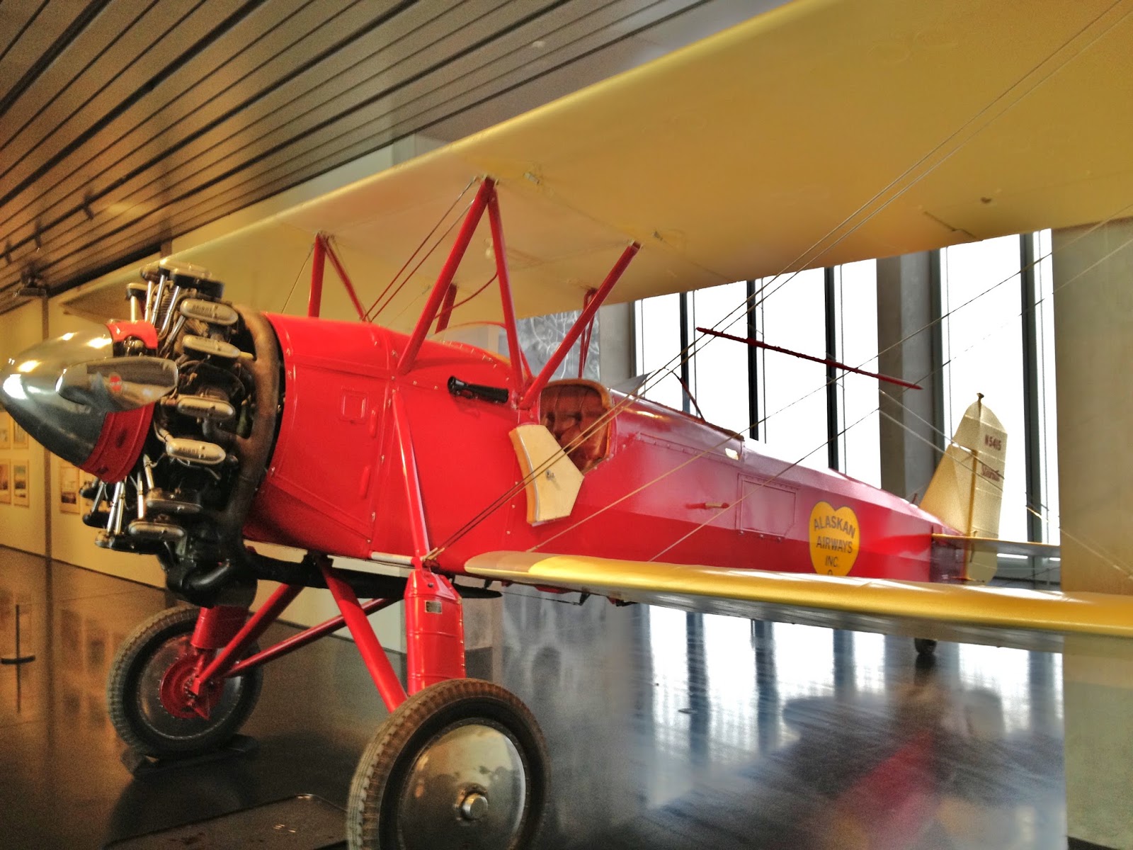
Curious about Alaskan history and native culture, Allison and I drove into nearby Anchorage and spent an afternoon at the Anchorage Museum.  There we viewed exhibits on a variety of topics including the divers tribes native to Alaska, and the vital, colorful role of aviation in Alaskan history.  We found the extensive displays of native clothing and artifacts particularly interesting.  That night we enjoyed an excellent meal at Orso - the same restaurant where I dined with my climbing team before our successful expedition to the summit of Denali (Mt. McKinley) in 2003.

Native clothing and artifacts
at the Anchorage Museum
An aviation exhibit at the Anchorage Museum
We spent our final day on the Kenai Peninsula exploring the former site of Portage, at the end of Turnagain Arm.  This area was the epicenter of the disastrous "Good Friday Earthquake" in 1964.  At a magnitude of 9.2 it was one of the strongest earthquakes in recorded history, causing 143 deaths, destructive tsunamis and extensive property damage.  The town of Portage was abandoned after sinking approximately ten feet and flooding as a result of the earthquake.  We viewed several nearby glaciers, including the Portage Glacier and beautiful Portage Lake which lies below it.  We also walked through the Alaska Wildlife Conservation Center, home to many bears, reindeer (caribou), bison and other animals.

Viewing Portage Lake and the Portage Glacier
A black bear at the Alaska Wildlife Conservation Center
Over our week on the Kenai Peninsula, Allison and I had the opportunity to explore the region's many attractions thoroughly but at a leisurely pace.  At the end of the week, we were excited to begin the next phase of our journey: a trip through Alaska's Panhandle and down the Inside Passage on the wonderful Alaska Marine Highway ferry system.

A mountain lake on the Seward Highway
  

Friday, July 5, 2013

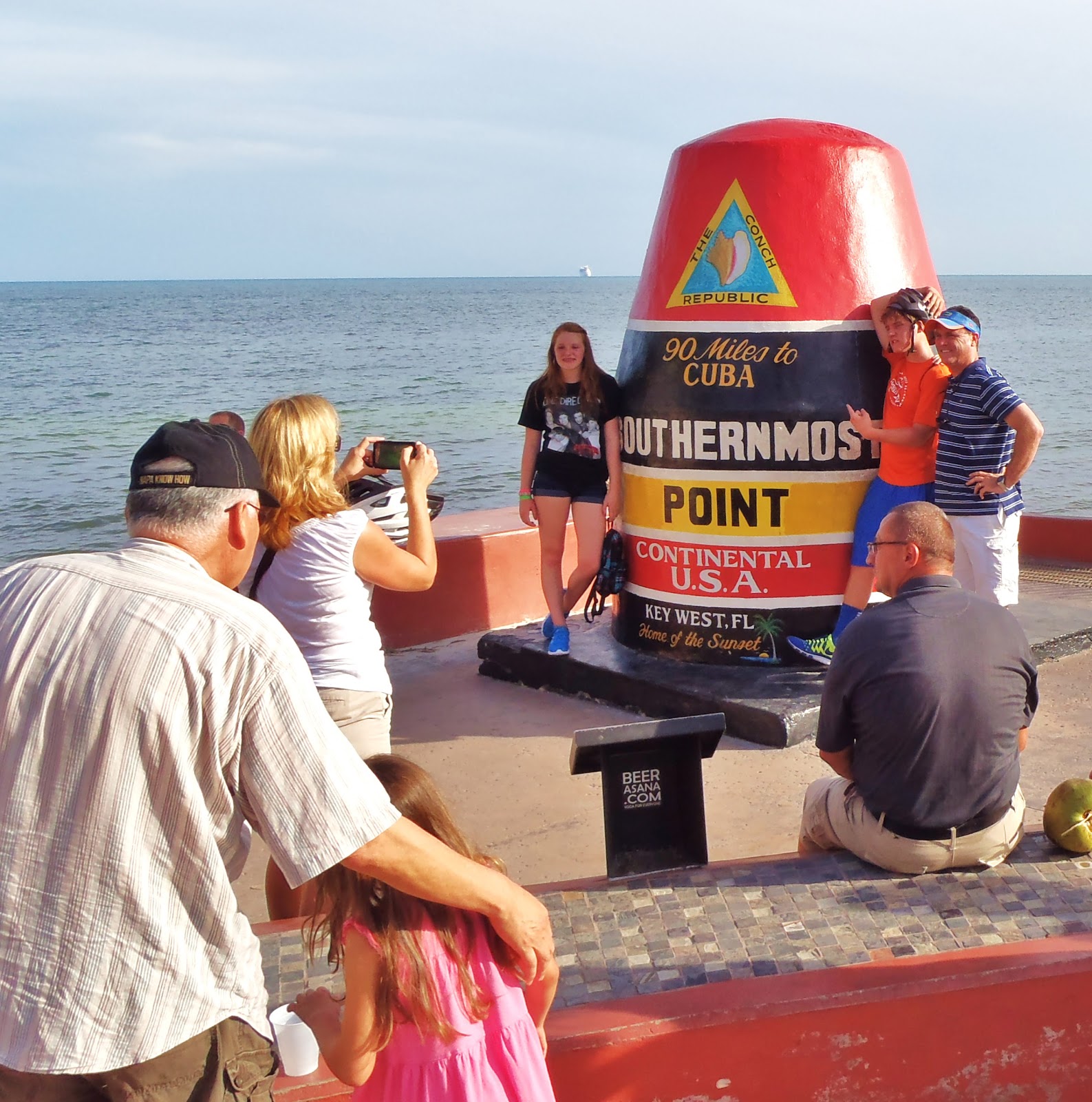
Check In from the Southernmost Point, in Key West

The Southernmost Point in the continental United States


Jay's Spot Beacon
Latitude:24.54654
Longitude:-81.79745
GPS location Date/Time:06/27/2013 18:19:22 EDT

Message:Jay Meyer has checked in. At the time of this message he was OKAY at the location shown and did not need help.

Click the link below to see where I am located.
http://fms.ws/CfySW/24.54654N/81.79745W

If the above link does not work, try this link:
http://maps.google.com/maps?f=q&hl=en&geocode=&q=24.54654,-81.79745&ll=24.54654,-81.79745&ie=UTF8&z=12&om=1

Jay's Spot Beacon

You have received this message because Jay's Spot Beacon has added you to their SPOT contact list.

Ready for Adventure
FindMeSPOT.com

Check In from Miami's South Beach

Filming a variety show on South Beach


Jay's Spot Beacon
Latitude:25.79433
Longitude:-80.12600
GPS location Date/Time:06/26/2013 12:16:35 EDT

Message:Jay Meyer has checked in. At the time of this message he was OKAY at the location shown and did not need help.

Click the link below to see where I am located.
http://fms.ws/Cecc2/25.79433N/80.12600W

If the above link does not work, try this link:
http://maps.google.com/maps?f=q&hl=en&geocode=&q=25.79433,-80.12600&ll=25.79433,-80.12600&ie=UTF8&z=12&om=1

Jay's Spot Beacon

You have received this message because Jay's Spot Beacon has added you to their SPOT contact list.

Ready for Adventure
FindMeSPOT.com

Tuesday, June 18, 2013

Central Alaska

Denali National Park from the park road
In late April and early May, Allison and I spent four weeks traveling through Alaska and the Pacific Northwest.  This post describes the first portion of the trip: central Alaska, including Anchorage, Fairbanks and Denali National Park.  Our travels elsewhere in Alaska, and in Washington and Oregon, will be covered in separate posts.

Downtown Anchorage
Anchorage is a strategic crossroads for many international air routes
Following a late night arrival in Anchorage, we spent a day exploring the city.  Anchorage is in a dramatic setting, surrounded by mountains of the Chugach Range which were dressed in a thick white coat of snow.  The area was experiencing a bout of unusually cold spring weather, and scattered snowflakes fell as we explored the downtown stores and restaurants and the shoreline of Cook Inlet.  In addition to sightseeing we also stocked up for our upcoming travels, buying a cooler and some simple staples.
 
Denali from the Parks Highway

Mounts Hunter, Foraker and McKinley (Denali) in Denali National Park
After a day in Anchorage we began our drive north toward Denali National Park and, ultimately, Fairbanks.  We passed through Wasilla, an exurb of Anchorage perhaps best known for its former mayor: Sarah Palin.  Continuing north on the Parks Highway, we gradually left civilization behind and entered a beautiful region of wild snowy mountains and vast expanses of wintry taiga and tundra.  As we reached Denali National Park the forest thinned, and we enjoyed distant views of Denali (America's highest peak, also known as Mount McKinley) and other impressive peaks of the Alaska Range.

Entrance to the Denali Park Road

Panoramic view from the Denali Park Road


A chilly picnic spot on the Denali Park Road
Eventually we reached the Denali Park Road, off the Parks Highway between the tiny towns of Cantwell and Healy.  We were there early in the season, and due to late snow the road was only partially cleared and there were very few other visitors.  It was a special treat to drive through the huge park's dramatic scenery in near total solitude, at times the only humans in many square miles of remote wilderness.

Moose north of Fairbanks
Bald Eagle in the Chena River State Recreation Area
After our drive on the park road, we spent a night in Healy then continued north to Fairbanks.  Fairbanks is America's northernmost city, Alaska's second largest city and home to the flagship campus of the University of Alaska System.  We toured the campus, including its modern and impressive Museum of the North where I found a wonderful addition to my small collection of indigenous figures.

On the Angel Creek Trail
Approaching the Lower Angel Creek Cabin
 The Lower Angel Creek Cabin
(click here for video courtesy of the Alaska Department of Natural Resources)
Our exploration of Fairbanks and its surroundings took us to the northernmost reach of our journey, at Lower Angel Creek Cabin in the Chena River State Recreation Area.  On the road to the Angel Creek Trailhead we saw wildlife including a bald eagle and two moose.  Allison and I hiked for several miles over snow covered trail to reach the remote public use cabin, where we spent some time absorbing the sense of wilderness emerging from winter.  On another outing north of Fairbanks, we saw a section of the Alyeska oil pipeline and some unusual back woods structures!

The Alyeska oil pipeline north of Fairbanks
Someone's little piece of heaven?
After two nights in Fairbanks we headed back south to Talkeetna, an important doorway into Denali National Park.  Each summer, many mountain climbers fly from Talkeetna into the Alaska Range for expeditions on Denali and other peaks.  It was from Talkeetna that I began my own climb on Denali in 2003.  Allison and I explored the small town on foot, visiting attractions such as the climber's memorial, riverfront and National Park Service Ranger Station.  We also visited K2 Aviation at the Talkeetna Airport to make arrangements for flightseeing the next day.  At the airport we saw a variety of ski and bush planes used to service Alaska's interior.


The Susitna River in Talkeetna; Mounts Hunter, Foraker and McKinley (Denali) in background

The Fairview Inn in Talkeetna
Our flightseeing trip the next morning was a highlight of our trip.  Piloted by Captain Greg in a small DeHavilland Beaver ski plane, we flew over the mountains and glaciers of the Alaska Range for two hours.  Our flight first took us from Talkeetna to the Kahiltna Glacier, where we followed the most popular climbing route up the glacier toward Denali's summit.  We then crossed Kahiltna Pass and the Muldrow Glacier.

Mount Hunter and the Southeast Fork of the Kahiltna Glacier,
site of Denali Base Camp

Portions of Denali's West Buttress Route including Kahiltna Pass, Motorcycle Hill and Windy Corner

Captain Greg flew us close by spectacular peaks such as the Moose's Tooth, then brought us in for a ski landing on the Ruth Glacier.  We spent about 15 minutes at a climber's base camp on the glacier, snapping pictures in beautiful, clear but cold weather.  After watching another ski plane land to discharge climbers and gear, we took off again to fly out over the glacier and back into civilization.

With Captain Greg on the Ruth Glacier

Our K2 Aviation DeHavilland Beaver on the Ruth Glacier 
Excited from our wonderful flight over Denali National Park, Allison and I drove south from Talkeetna to Anchorage.  There, we spent a relaxing evening walking through the downtown and preparing for the next stage of our trip: Alaska's Kenai Peninsula, south of Anchorage between Cook Inlet and Prince William Sound.  
 
On the shore of Cook Inlet in Anchorage

Monday, May 27, 2013

Check In from Timberline Lodge

Timberline Lodge on Mount Hood
Jay's Spot Beacon
Latitude:45.33107
Longitude:-121.71155
GPS location Date/Time:05/24/2013 01:11:27 EDT

Message:Jay Meyer has checked in. At the time of this message he was OKAY at the location shown and did not need help.

Click the link below to see where I am located.
http://fms.ws/CAg6P/45.33107N/121.71155W

If the above link does not work, try this link:
http://maps.google.com/maps?f=q&hl=en&geocode=&q=45.33107,-121.71155&ll=45.33107,-121.71155&ie=UTF8&z=12&om=1

Jay's Spot Beacon

You have received this message because Jay's Spot Beacon has added you to their SPOT contact list.

Ready for Adventure
FindMeSPOT.com

Check In from the Alyeska Resort

The Alyeska Resort in Girdwood, Alaska
Jay's Spot Beacon
Latitude:60.97042
Longitude:-149.09758
GPS location Date/Time:05/08/2013 18:38:52 EDT

Message:Jay Meyer has checked in. At the time of this message he was OKAY at the location shown and did not need help.

Click the link below to see where I am located.
http://fms.ws/B-lYH/60.97042N/149.09758W

If the above link does not work, try this link:
http://maps.google.com/maps?f=q&hl=en&geocode=&q=60.97042,-149.09758&ll=60.97042,-149.09758&ie=UTF8&z=12&om=1

Jay's Spot Beacon

You have received this message because Jay's Spot Beacon has added you to their SPOT contact list.

Ready for Adventure
FindMeSPOT.com

Check In from the Space Needle

Seattle's Olympic Fountain and Space Needle
Jay's Spot Beacon
Latitude:47.62022
Longitude:-122.34944
GPS location Date/Time:05/20/2013 13:45:46 EDT

Message:Jay Meyer has checked in. At the time of this message he was OKAY at the location shown and did not need help.

Click the link below to see where I am located.
http://fms.ws/C7tRt/47.62022N/122.34944W

If the above link does not work, try this link:
http://maps.google.com/maps?f=q&hl=en&geocode=&q=47.62022,-122.34944&ll=47.62022,-122.34944&ie=UTF8&z=12&om=1

Jay's Spot Beacon

You have received this message because Jay's Spot Beacon has added you to their SPOT contact list.

Ready for Adventure
FindMeSPOT.com