Tuesday, September 10, 2013

Mount Adams via King Ravine

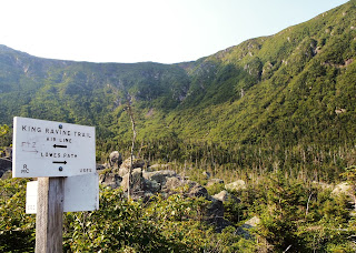
King Ravine, with the Great Gully at center

On August 20, 2013, I climbed to the summit of Mount Adams in New Hampshire.  Mount Adams is the second highest mountain in the northeast; it is located north of Mount Washington, in the Presidential Range.

Waterfall along the King Ravine Trail
I reached the summit through King Ravine, a deep bowl on the mountain’s north side.  I hiked on the King Ravine Trail, a rugged trail which follows a rocky stream and passes among many huge boulders at the base of the ravine.

Boulder cave on the Subway
(note arrow trail marker at center) 
Hiking through King Ravine, I took a short detour on the Subway Trail which squeezes through several narrow cracks and caves formed by the jumbled boulders.

Waterfall in the Great Gully
To ascend the ravine’s steep wall, I took the spectacular Great Gully Trail.  The AMC White Mountain Guide describes the Great Gully Trail as “extremely steep and rough” and “lightly used and marked,” with “one particularly difficult scramble.”  I found the challenging trail fun and exciting!

Mount Madison from Mount Adams
From the top of the Great Gully Trail, it was a short hike through Thunderstorm Junction to the top of Mount Adams.  The summit was partially obscured by blowing clouds, but I still enjoyed a dramatic view of nearby Mount Madison.

Randolph Valley from the Air Line
(King Ravine left and Durand Ridge right of center)
I descended from the summit back to my car on the Air Line, a particularly scenic trail which follows the crest of Durand Ridge.  From the Air Line, I had an excellent view of my ascent route up the Great Gully in King Ravine.


King Ravine from the Air Line
(Great Gully slightly right of center)


No comments:

Post a Comment